Severn and Wye Railways
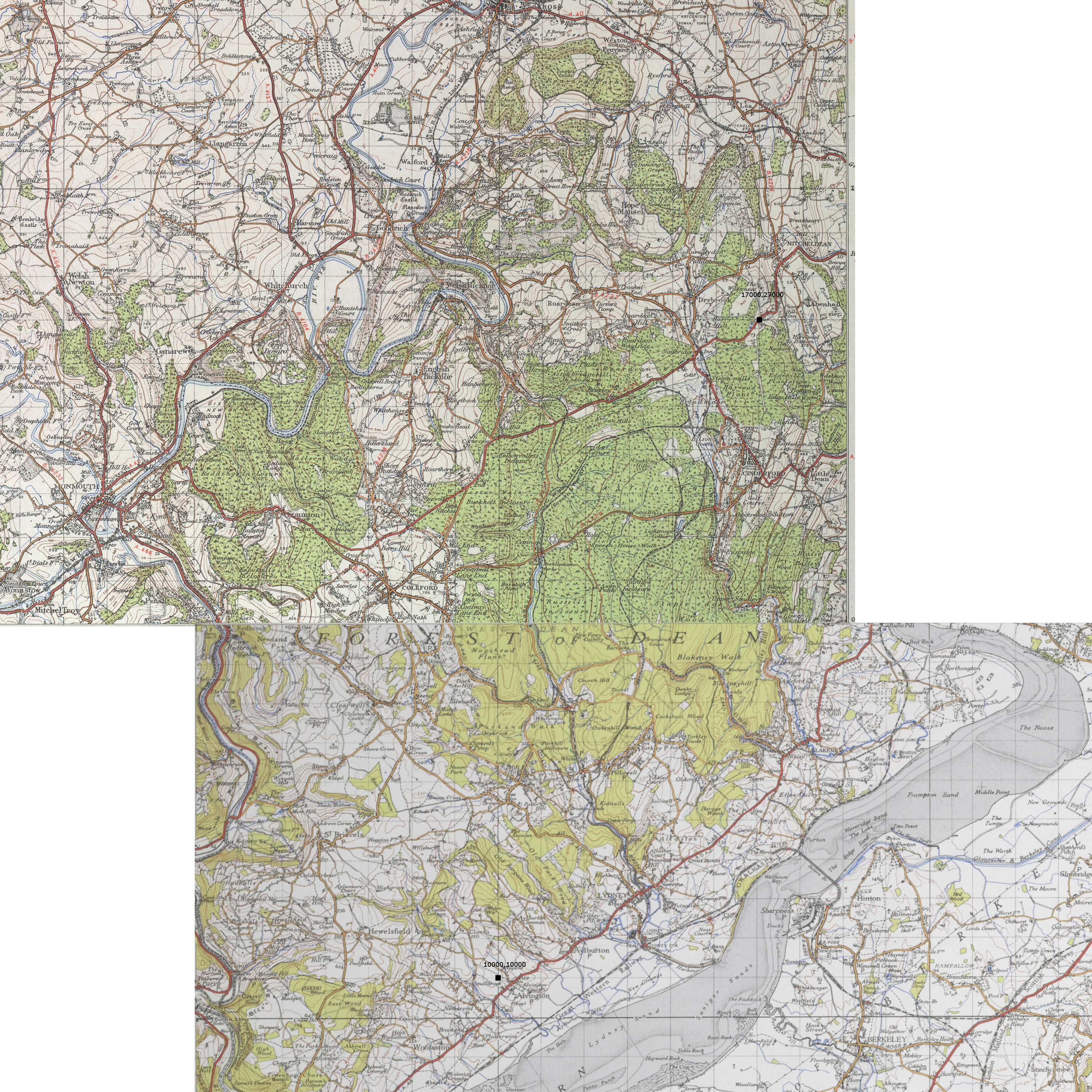
<h3>Severn and Wye Railway</h3> <p>After having followed the whole procedure of the introduction to Rail3D, I decided it was time for my own layout. Using my own trial and error to get used to the program. Question that immediately followed was: Which line? There were several points that I wanted to keep in mind: I wanted to create a line from about the start of the 20th century, this would involve steam, coal-lines and semaphore signals. Searching about on internet I found many disused railways, many of them situated around Britain, or USA. At one moment I found an interesting railway, with its own transport company, at its first completely not connected to any other company around Britain. This was the Severn and Wya Railway. And from some photographs that I found on the internet: A wonderful sight to see as well: Many small brooks, rivers and streams even some tunnels, bridges and forests. </p> <p> </p> <h3>History of the SWR</h3> <p>A small summary of the history without trying to repeat Wikipedia or other pages on the web.</p> <p>In 1810 a small tram connection was started by the Lydney to Lydbrook Railways. Following the banks of the (small) river Lyd it went from the harbor of Lydney up to Lydbrook 25km inland. covering an altitude of over 200 meter in height. Around 1868 another company started constructing along side the tramways with broad-guage tracks: GWR. Up to the end of 19th century the tram line went bankrupt and the broad-gauge were all changed into standard-gauge. Around 1900 the line extended further towards Cinderford, but only for a short while because after 1929 all passenger services were closed, in 1956 the freight train did not run the lydbrook branch again. In 1960 the bridge over the Severn collapsed, and in 1976 the last train was buried. </p> <p> </p> <h3>The Layout</h3> <p>As I said before: I wanted to line to be around 1900. By that time the Severn and Wye Railway was build up with the following tracks: Sharpness to Cinderford, Cinderford to Lydbrook Junction and back. </p> <p> </p> <p><img src="/upimages/wiki/projects/Severn-Wye-Railways.jpg" alt="" width="479" height="770" /></p> <p>To get the best result, I had to dive into the history of the tracks, and because the track is a good distance away from home I had to use Google Earth, Maps and UK-Survey Maps to get as much information about the route and the way the tracks had been. </p> <p> </p> <p><img src="/upimages/wiki/projects/DeanForestRwyMap.jpg" alt="" width="303" height="576" /></p> <p>After downloading the maps and other material I needed for the project, I calculated distances on the map and worked out a lower-left point and an upper-right point. Worked the map into Rail3D with the Map-tool. Than started to create the landscape as good as it get. This was, as we say in dutch: 'A monks business'. Following every height-line on the map I gave in every so often a height-point for the terrain. From Sharpness over the Severn following height-line after height-line to shape the land. </p> <p> </p> <p> </p>
Having almost all the lines of the landscaping followed over the full map, it was time for the tracks to be laid. All tracks I laid with 'Lay track on ground level'. Truth be told I could not have made this layout without the proper help of internet, many people of Rail3D who'd helped me with the tiny problems I'd had and many part of the track as far as it is now, is filled with the work of others. At this point I need to look further into working with SketchUp, or the Rail3D Editor and programs like that, for building the houses, cities, people and engines.
Erwin 27/07/2015 16:25:53